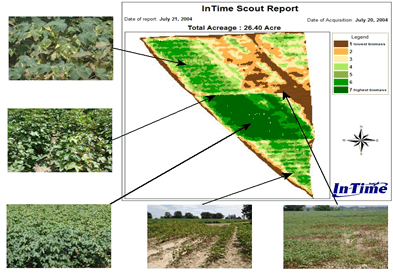
The seven color image above shows a classified aerial image
of a cotton field in northern part of the Mississippi Delta. The
image was flown at 12,000 feet with a two-meter resolution.
A herbicide was accidentally applied
over the top while spraying for insects. Spraying was performed
with two sprayers. The dark green area (Class 6 & 7) in the
classified image is where no herbicide had been applied. The image
helped the grower to assess the extent of the damage in this
particular field.
Several
other growers have used InTime's imagery for the purpose of
assessing damage that had occurred to their crops by hail,
incorrect chemical applications, poor germination, etc. The
classified image, in conjunction with pictures of their field(s),
will greatly benefit growers in their claim of crop damage.
Download
printable version

|

